
 How to resolve AdBlock issue?
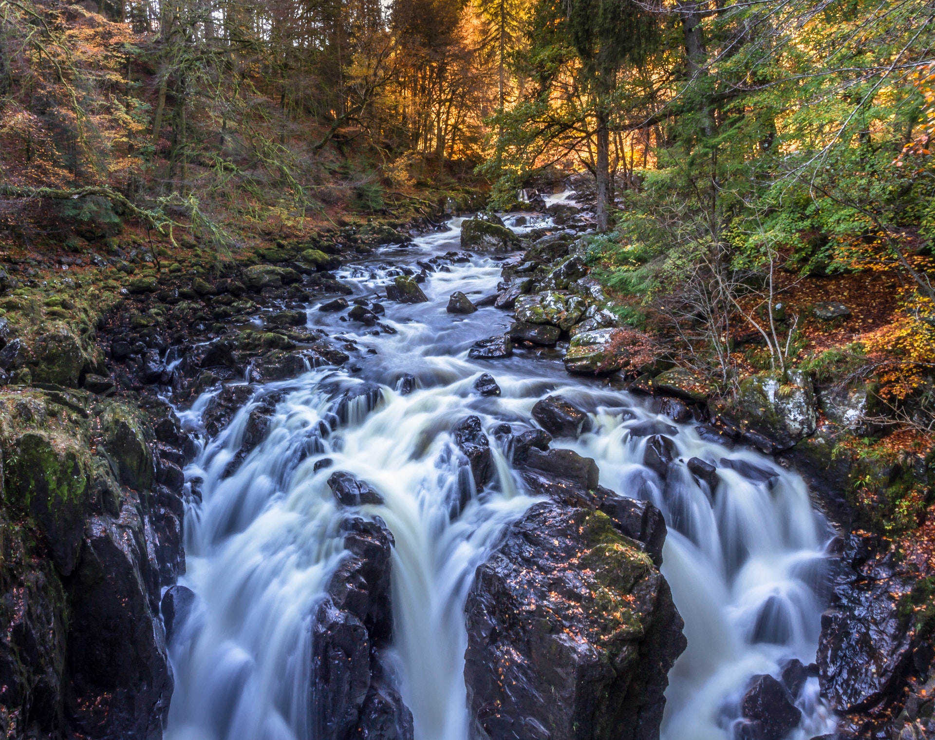
High Falls Access Area Attractions NC
High Falls from High Falls Access Area
High Falls slides 120 feet down an inclined plane of granite. The falls and the Covered Bridge can be viewed from the trail and the picnic shelter.
Hikers
Take High Falls Loop to the intersection. (Foot traffic only)
Continue on the multi-use trail to the viewing area and picnic shelter.
Bikes, Horses and Hikers
Take Buck Forest Road.
Turn left on the High Falls Loop and take an immediate right on High Falls Loop to the viewing area & picnic shelter.
Total distance is 0.5 miles either way.
From the shelter, access the base of High Falls by going down High Falls Loop and turning right on Base of the Falls.
ONCE AT THE BASE, DO NOT ATTEMPT TO CROSS THE RIVER OR CLIMB UP THE ROCKS
Triple Falls from High Falls
This 120-foot waterfall features three cascades with picnic shelter and 112 stairs to the center of the falls.
Hikers
From the High Falls Shelter, take the path below the shelter and turn left 0.5 miles on High Falls Loop.
Go right on Triple Falls Trail.
Total distance is 0.7 miles.
Bikes & Equestrians
Backtrack to High Falls Loop and turn left.
Go right on Triple Falls Trail.
Total distance is 0.8 miles.
Stay out of the water and don’t climb the rocks next to the falls
Return to High Falls Access Area
Bikes, Horses and Hikers from Triple Falls
Return by going up Triple Falls Trail and right on High Falls Loop and right on High Falls Loop (Foot Traffic only) or Buck Forest Road for.
Round trip to High Falls and Triple Falls 2.3 miles for hikers and is 2.4 miles for bikers and horses without going to the base of High Falls.
Covered Bridge from High Falls Access Area
Hikers
Take High Falls Loop for 0.3 miles to the intersection. (Foot traffic only)
Cross the Trail and continue on the multi-use High Falls Loop for 200 feet and turn right on Covered Bridge Trail.
Total distance is 0.5 miles.
Bikes, Horses and Hikers
Take Buck Forest Road for 0.5 miles.
Covered Bridge from High Falls
Take High Falls Trail toward the parking lot and turn left on Covered Bridge Trail .
Total distance is 0.4 miles.
Hooker Falls from Triple Falls (Foot traffic only)
The Little River drops off a 12-foot ledge at Hooker Falls before flowing into Cascade Lake further downstream. Hooker Falls is the fourth waterfall on a 3.3 mile section of the Little River.
Go down Triple Falls Trail. Go under the highway bridge and turn right on the Trail Bridge.
Turn left on Hooker Falls Road to the base of the falls.
Total distance is 0.7 miles.
Return to High Falls Access Area (Foot traffic only)
Return by going up Hooker Falls Road.
Turn right across Trail Bridge on Triple Falls Trail.
Turn right on High Falls Loop bearing right near Buck Forest Road.
Total distance is 1.7 miles.
Round trip to High Falls, Triple Falls and Hooker Falls is 3.6 miles.
Grassy Creek Falls from High Falls Access Area
Grassy Creek Falls is a cascade on the Grassy Creek downstream from Wintergreen Falls.
Take Buck Forest Road past the Covered Bridge.
Turn left on the Lake Imaging Road and a left on Grassy Creek Falls Trail to the falls. (Foot traffic only)
Total distance is 1.5 miles.
Bridal Veil Falls from High Falls Access Area
Bridal Veil Falls is perhaps the most interesting waterfall in the DuPont State Recreational Forest, with a four-foot overhanging ledge on the upper section and a long, shallow whitewater incline along the lower section. One can view the upper falls from the platform near the end of the trail.
Take Buck Forest Road past the Covered Bridge, turn right on Conservation Road and right on Bridal Veil Falls Road.
Total distance is 2.3 miles.
Or go to Fawn Lake Access Area for many more interesting ways to Bridal Veil Falls.
WARNING—Swimming at Bridal Veil Falls is not recommended because of large rocks and swift currents. Rocks are extremely slippery when wet
Three Lakes from High Falls Access Area
Lake Dense
Five-acre Lake Dense is off the beaten path. It has a picnic shelter and fishing dock and a very good view of Joanna Mountain.
Take Buck Forest Road past the Covered Bridge.
Turn right on Conservation Road.
Go left on Joanna Road and right on Three Lakes Trail.
Total distance is 1.2 miles.
A more interesting route is to turn left off Conservation Road and take Pitch Pine Trail .
Total distance this way is 1.8 miles.
Lake Alford
Lake Alford is 0.3 miles further down Three Lakes Trail.
Lake Julia
There is a view of Lake Julia and the spillway from Three Lakes Trail as it continues to Conservation Road.
Turn right at Lake Alford .
Return to the parking lot
Turn right on Conservation Road.
Go left on Buck Forest Road.
Total round trip is 3.2 miles by the direct route and 3.8 miles via Pitch Pine Trail.
Lake Julia from High Falls Access Area
Lake Julia is 99 acres and the largest lake in the forest. What is known as the Lodge is the present Ranger Station that is located near the end of Lake Julia Road.
To Dam
Take Buck Forest Road past the Covered Bridge, turn right on Conservation Road and left on trail just beyond the spillway bridge.
Total distance is 1.4 miles.
One can walk across the dam but no horses or bikes
https://www.dupontforest.com/To Ranger Station
Take Buck Forest Road past the Covered Bridge, turn right down Conservation Road and left on Lake Julia Road to the Ranger Station.
Further down Lake Julia Road leads to picnic tables and pier.
Total distance is 2.2 miles to the Ranger Station and 2.4 miles to the picnic tables and pier.
https://www.dupontforest.com/explore/key-attractions-2/high-falls-access-area-attractions/
**Information credit: Friends of Dupont Forest
Find more information @ https://www.dupontforest.com/